Friday, 22 August 2014

The 'Coral Coast'

From inland Pilbara, we then headed back out to the coast - the 'Coral Coast'. So we missed the coastal strip between Port Hedland and Exmouth which includes Karratha and Dampier and we have been watching 'Red Dog' which is set in Dampier, that will have to be for next time. From Exmouth all the way down to just north of Carnarvon is the Ningaloo Reef. This is Australias largest fringing reef system and certainly the most accessible for anyone without a boat. So there is great snorkelling just off the beach or the rocky coastline, unlike Great Barrier Reef where you have to get charter boats etc. So we have been doing a fair bit of snorkelling and getting to see an amazing array of the most beautiful and colourful fish and lots of coral.

First stop was Coral Bay, which while a beautiful location, was a jam packed caravan park where we had 3 nights which was probably 2 nights too many for me. At least the kids enjoyed the very warm pool and the jumping pillow. Also it was very windy and the water was choppy so we elected not to do the 'Swim with the Manta Ray' tour because it probably would have been very unpleasant on the boat (although undeniably spectacular swimming with Manta Rays....next time!). It was the off-season for swimming with the whale sharks, that is up until June. The fish feeding was the highlight; feeding huge (50cm) fish, a whole heap of them swimming around and through your legs. I even got a bite on my knee because one of my various scrapes obviously looked like one of the pellets to them.

Next stop was far better: back up coast, via Exmouth, to Cape Range National Park. Ahhhh, now THIS is the place to be. However apparently that's what a lot of people think and don't ever think you can just turn up at this National Park and find a campspot. It all has to be booked online and there is unlikely to be anything available on the spot. We were lucky we caught wind of this before arriving and were able to book 3 nights (but needed to spend those 3 days at Coral Bay waiting our spot to become available) but lots of people just don't know and therefore can't stay.

Campspot number 20 at Kurrajong, Cape Range - beautiful! Just over the dune from the beach. The campsite was in fact like a little community complete with very friendly 'camp hosts' and drinks at 5.30 every evening up on the 'table on the hill' where we watched the sunset, chatted about our days activities or, as in the case of one evening, had poetry recital.


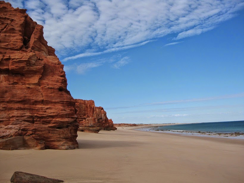
Kurrajong, like all the beaches in Cape Range, had the most beautiful turquoise water with darker patches under which was the reef. Waves broke further out at the outer part of the reef so that the water near the shore was generally very still and good for snorkelling. Each morning at around 7am, just after sunrise, I swam some 'laps' at Kurrajoing and enjoyed mucking around and chasing the fish. Here are some shots of Kurrajong.


During the days we took picnic lunches and headed to either Oyster Stacks, Turquoise Bay or Sandy Bay, which was the kids favourite, and swam or snorkelled. There was a great number of fish, of various types and of the most brilliant colour assortment. At Turquoise Bay Drift you just entered the water at one end of the beach and just let the water pull you down to the other looking at the various fish on the way.


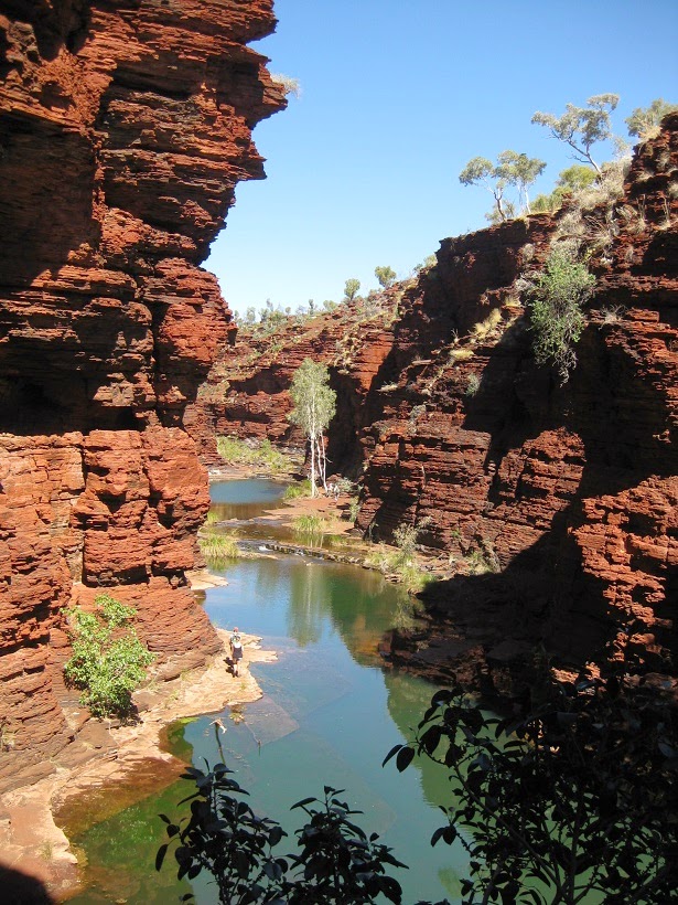
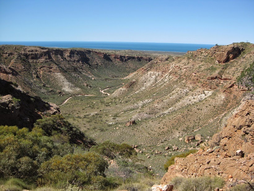
As well as beaches and snorkels, we also got in a few walks in Cape Range. The following photos show: 1. looking back towards the coast (west) along the s-shaped dry riverbed at Mandu Gorge, 2. Looking back towards the coast (west) at Yardie Creek, which is permanently filled and 3. Charles Knife Canyon, which is on the east side of the park, back around via Exmouth and looking out towards the east coast this time (peninsula). We did this last one on our way out with the caravan - a long steep climb, but quite spectacular.


Some shots for the grandparents; sunset at Cape Range


and finally a poor little crab who had lost a pincher and some legs..

Monday, 11 August 2014

Karijini National Park...Mining...Asbestos...

Albert Togolini Rest Area was a spectacular place to stay and made a great base for us to explore the nearby Karijini NP. From water front views one night to this view of the ranges the next.


However, in this very similar area to Karijini, is the town of Wittenoom, today a semi-ghost-town. Midnight Oil fans remember 'Blue Sky Mining'; both the song and the album. The song was inspired by Wittenoom. Blue Aesbestos has been mined there for decades and it was once had a thriving population of 30 000. To date 2000 past residents have died of mesothelioma with the 40 year incubation period not yet over and more expected cases to come in the near future....apparently the government is trying to get the remaining 5 permanent residents to leave. But it all seems a bit hush hush here. We have not seen any particular warnings at Visitors centres, or the Parks or anywhere. It was only in our road atlas that there was a warning not to go to Wittenoom because of 'blue asbestos dust that may cause cancer', that we did a bit more further research. The Wittenoom Gorge is SO close to the gorges of Karijini, they all connect. Wandering around Karijini, which is truly spectacular, blue layers of rock are very obvious. The stockpiles in Wittenoom which cause the risk, one can only hope neighbouring Karijini is in no way effected by these regardless of what way the wind is blowing......

The photos wont capture how stunning this national Park is. The rocks, their shape and forms are amazing. They contain so much iron ore that they look rusty in colour, and they are layered (with blue) and in very geometric, slab like shapes. There were lots of swimming opportunities in the most beautiful gorges and pools.


We are now in Paraburdoo, 140km south west of Karajini via Tom Price. Its a 40 year old purpose built mining town. Apart from the normal service occupations such as medical and teachers etc, everyone works in the mine. A lot of them fly in and fly out. The population are all wearing fluoro vests. Its been fascinating talking to locals about their work and lifestyle here which doesn't seem too bad at all.. They very much get looked after by their employer Rio Tinto. We ate in the miners Mess last night. What a great meal! And what a positive energy and caring atmosphere is created for employees, complete with recommendations of which food to 'eat more of' and which foods to 'eat less of'. As for us, we just ate everything, and certainly too much of everything. It was a pupil free day today so there were lots of kids about and we chatted to some at the skate park. We stay at the Rio Tinto caravan park which doubles as temporary accommodation for relocated miners. Facilities are amazing. Everything is neat, clean, new and orderly. Cem loves it.

Yesterday we did a tour of the Rio Tinto mine in Tom Price and saw some very big machinery and a lot of iron ore.


Also partially climbed Mt Bruce, second highest peak in WA, great view of a 240 carriage iron ore train on it's way to Dampier port, then took the 4WD track to the top of Mount Nameless which is the highest peak in WA at 1116m above sea level. The aboriginal people, according to info at Karijini Visitors Centre (nice building!), are a bit annoyed that its been called Mt Nameless, they say, of course its got a name, its Jarndunmunha, if they'd asked us we would have told them..... I must say, Mt Nameless is a bit of a stupid name. Cem made enquiries about Wittenoom at the Tom Price Visitors Centre. The lady who had been so cheery to the customer before, suddenly cooled down and said to Cem, I cannot say anything about that area, Cem pressed for a bit but her lips were sealed....

Heading South

With mixed feelings we now start to head south - that's because we now head away from the tropics and it will just get cooler, but also because there is more of this big state of WA to see and visit. So now we move away from the Kimberley and head into the Pilbara. On the way down from Broome to Port Hedland there are some extremely good 'free camp' spots and so we therefore get a very good first impression of the Pilbara councils. As you get closer to Port Hedland the council even starts providing free WiFi at these 'Welcome Rest Areas' or 24 hour campspots so you can sit under the shelters and catch up on your emails etc! The best two were De Grays, lovely campspots on the De Gray River and Albert Tognolini, fabulous view over the ranges, on the way to Karijini. The stretch between Broome and Port Hedland is about 700km and was once one of Australias loneliest roads, the Sandfire Roadhouse was opened by an enterprising young couple in the 70's and has now become quite an icon and still owned by the same family. Along this stretch is also Eighty Mile Beach. I have just converted this to kms: 129kms!! Of beach. A vast expanse of Beach with an amazing array of the most beautiful shells we have seen.


Port Hedland marked our introduction to the mining industry of WA. We watched huge ships, they were 300m long, leave the port laden with iron ore and heading to China. The most enormous pile of salt ever to be seen was also a feature there.


Another delightful place to camp at Port Hedland. This is the view from the caravan door:


and the next morning as were having breakfast a herd of dolphins swam by.


Spent a morning at the South Hedland Aquatic Centre, beautiful Olympic size pool almost to ourselves, what great facilities these mining towns have, can see there is a lot of $s here, and from Port Hedland its inland to Karijini National Park and surrounds, which includes some significant mining areas such as Tom Price among others.

Wednesday, 6 August 2014

Dampier Peninsula - Cape Leveque

There is a knobby bit of land to the north of Broome which is quite distinct if you look at a map of Australia. It is called the Dampier Peninsula. It presented an opportunity for us to dust off our tents and sleeping mats, dump the van and head off in the car up the dirt track (about 200km) of the peninsula. So after bidding farewell to the van which we stored at 'Broomes Gateway', a fledgling campground on the outskirts of Broome for $7/night, we were off for 5 nights in the tents. Our first campsite at Gumbarnun was on the water but because it was on the east side of the peninsula, the water was not swimmable due to the possibility of both crocs and sharks. So while the sunrise was magnificent and we had a waterfront position and we made good use of the story telling corner, we did push on after one night in search of swimming opportunities.


The peninsular is largely aboriginal-owned land with several aboriginal communities, several sizeable privately owned properties and an endless supply of the most beautiful, deserted beaches that have snow-white sand and turquoise water. We visited the community of One Arm Point right at the top of the peninsula. What a progressive community and what a huge difference from the communities of Central Australia and the Alice Springs area that we had experienced. I am sure it is the coastal environment that contributes to making it seem so much lighter, so much more pleasant and so much less oppressive. There is a fee/permit to get into the community, and perhaps it is also this money coming in, which I guess in a way gives the place a sense of worth, that contributes to the coherence of the place. The location is also undeniably beautiful. The Trochus Hatchery was fascinating. Trochus is a shell which only the people of this area (Bardi Jaawi) are permitted to collect, there were also huge tanks of various fish including 'Nemo', the clown fish. The huge barramundies sucked the squid with the swiftest, fastest of movements.


We also visited Cygnet Bay Pearl Farm, a posh, non-aboriginal-owned pearl farm which sends its pearls all round the globe. Then we headed to our next camping spot which was by far our favourite. It was the 'beach shelters' at Kooljaman, another aboriginal enterprise, and also the actual area of Cape Leveque (although people seem to call the whole pensinsula 'Cape Leveque') on the west (top) side of the peninsula. It was possible to swim here although we not quite sure why the sharks couldn't find their way from the east to the west side... Our beach shelter was right on the beach;


As well as swimming, the beach was great for kite flying:


Sunrise at 'our' beach


This is the first, very tame, snorkelling expedition, and method of transport there and back:


Our second snorkelling expedition was a bit wilder, together with the G.... family of Austinmer (cheers Mark, Miriam, Sandon and Luca!) we ventured out along a rock outcrop that headed out to sea several hundred metres, saw some great fish, clams and coral, but had a bit of trouble returning due to the very fast moving tides and the razor sharp barnacles. We eventually stumbled up onto the sand with various bloodied body parts but glad to all still be alive. The next day required me to convalesce by laying flat on my back on the beach for the entire day in which time I read, but also counted the cuts, scratches, nicks and scrapes which amounted to 107 of which approximately half were on the soles of my feet.

There was another beach at Kooljaman but swimming was not advisable here. It was called 'Western Beach'.


We headed back down the peninsula to our final camping spot at Middle Lagoon with a detour to Lombadina, the most beautiful community I have seen which started out as a christian mission and has the most delightful bush-architecture church. Similarly Beagle Bay was an ex-mission, now a community, but its church was a lot more European. At Middle Lagoon, apart from laying on the beach, we found time to get a bit of maths mentals in. Note also that the hammock was always in high demand and each of the kids all managed to sleep an entire night in it.


Here's a picture of the kids as we bade each other farewell at Middle Lagoon, thanks guys, it was a fun few days with you!